The river itself is about 380 feet above sea level here. The surrounding hills tower from 200 to 1000 feet above it. The scenery is beautiful. The north bank (Maryland) is part of the C&O Canal National Historic Park and is almost totally undeveloped. The south bank (West Virginia) has a railroad and some campgrounds, but both are very well hidden in the trees. If a train isn't going by (and for most of our trip they weren't), it is possible to imagine yourself in pre-colonial times, exploring a river that European eyes hadn't seen before.

|
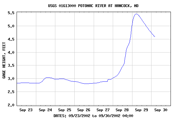
As we went upriver, we met the flood surge from the previous 2 days' rain coming downriver. The water
rose almost 2 feet during our trip, which was less than the tides we normally experience on the Patuxent.
However, the current through some of the riffles approached 5 mph and made for some really slow going
at times (at least upriver).
In case anyone is wondering, we always go upriver the first time on a new part of a river. This gives us a chance to scout what we're getting into and an automatic out if we approach a bad stretch (just stop paddling and the current pushes us away from trouble). |